1.
Cristoforo Colombo,
1451-1506.
Epistola Christofori Colom . . .
Rome: Stephan Plannck,
1493.
Lilly Library call number:
E116.1 1493 Vault
2.
Cristoforo Colombo,
1451-1506.
Epistola Christofori Colom: cui etas nostra multum debet: de
insulis Indie supra Gangem nuper inventis.
Rome: Stephan Plannck, 1493.
Lilly Library call number:
E116.1 1493a Vault
Fernando and Isabel made sure that Columbus's First Letter from America
would be widely distributed and read throughout Europe. Probably at
their initiative, the book went through nine editions within
a year: three editions in Rome, one in Antwerp, one in Basel, three in
Paris, and another in Basel in 1494. An Italian translation in poetry by
Giuliano Dati had three editions in 1493 (one in Rome and two in
Florence). A German edition appeared in Strassburg in 1497. A second
edition in Castilian appeared in Valladolid in 1497.
This copy of the second Plannck edition in Rome is open to the final
page, which describes Columbus as "Christopher Columbus, Commander of
the Ocean Fleet."
3.
Bernardino Carvajal, 1456-1523.
Oratio super praestanda solenni obedientia sanctissimo . . .
Alexandro papae VI. . . Rome:
Stephan Plannck, 1493?
Lilly Library call number:
DP161.5 C3 Vault
In a further effort to assure Castilian sovereignty over the newly
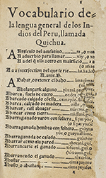
discovered islands, Fernando and Isabel appealed to the
fifteenth-century's equivalent of an international arbiter, Pope
Alexander VI. Their ambassador to the papacy, Bernardino Carvajal, made
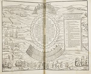
this speech to the pope on June 19, 1493, in which he presented
Castile's claims and requested that Alexander confirm Castilian
possession of the islands.
The appeal was successful. Alexander issued a papal decree, Inter
caetera, confirming Castilian possession of the islands that Columbus
had discovered and any other islands or continent that Castilians might
discover in the future beyond an imaginary line in the Atlantic Ocean.
This Line of Demarcation, according to Inter caetera, was drawn from the
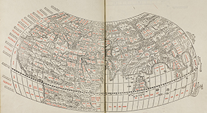
Arctic or North Pole to the Antarctic or South Pole, one hundred leagues
south and west of the Azores and Cape Verde Islands.
Spanish appeal to the papacy had the intended effect. Portugal, worried
that the papal decrees gave Castile a right to the eastward route to the
Indies and to lands off the West African coast, agreed to negotiate
directly with the Spanish monarchs. On June 7, 1497, Castile and
Portugal signed the Treaty of Tordesillas, setting the Line of
Demarcation 370 leagues west of the Cape Verde Islands. Through this
compromise, Castile secured possession of Columbus's discoveries,
including eventually North and South America, while Portugal retained
rights to lands discovered east of this line, which included sub-Saharan
Africa and the East Indies, to which, one month later, the Portuguese
king would despatch Vasco da Gama.
4.
Carlo Verardi, 1440-1500.
In laudem serenissimi Ferdinand hispaniane regis Bethicae
& regni Granatae obsidio victoria & Triu[m]phus. Et
de insulis in mari Indico nuper
inuentis. Basel: Johann Bergmann
de Olpe, 1494
Lilly Library call number:
PA8585.V39 H57 1494 Vault
5.
Cristoforo Colombo, 1451-1506.
Eyn schön hübsch lesen von etlichen insslen die do in kurtzen
zyten funden synd durch de künig von hispania . . .
Strasbourg:
Bartholomäus Kistler, 1497.
Lilly Library call number:
E116.1 .G4 1497 Vault
This is the first German edition of the First Letter from America.
Typical of German printed books, it bears a beautiful woodcut
illustration on the frontispiece. It is the first printed work to
introduce a religious motif in the American story; Christ addresses King
Fernando and his courtiers.
Spanish publishers knew that the Columbus voyage was a Castilian
enterprise, and that Queen Isabel of Castile was the ruler of the new
islands. But publishers in other parts of Europe could not seem to
understand that Columbus reported principally to the queen, not the
king.
6.
Fernando V,
1452-1516, and
Isabel I,
1451-1504.
Libro en q[ue] esta[n] copiladas algunas bullas de n[uest]ro muy
s[an]cto padre co[n]cedidas en fauor de la iurisdicio[n] real de sus
altezas, & todas las pragmaticas q[ue] esta[n] fechas para
la buena governacion reyno. Alcalá de
Henares: Lançalao Polono,
16 November 1503.
Lilly Library call number:
DP161.5 S73 Vault
Having acquired formal recognition of Castilian sovereignty over La
Española, Fernando and Isabel authorized colonization of the
island. A colony would constitute effective occupation—one of
the most important proofs of sovereignty. Events on La Española from
1493 through 1497, however, punctured the euphoria with which Spanish
colonists had volunteered for the second voyage. The fleet made a fast
safe crossing, but found the thirty-nine men left behind in La Navidad
had been killed either by disease or by the local Indians. The natives
that Columbus had described as meek and gentle in the First Letter from
America turned out to be hostile and dangerous.
The environment also proved dangerous. More than three hundred Europeans
became seriously ill after they went ashore, including Columbus, and
many died. Columbus diverted his energies into conquering the Indians
and exploring further west, where he still expected to find the Asian
continent. He left the administration of the colony in the hands of his
brothers Bartolomé and Diego Colón, who had just arrived from France and
Italy, never having lived in Spain.
The Spaniards who had come to colonize the island became dissatisfied
with the Columbus brothers' authoritarian and uninformed rule. Groups of
colonists moved away from Columbus's headquarters city of La Isabela to
form squatter settlements, but the Columbus brothers attacked them and
arrested them as rebels. The colonists felt that the denial of their
rights as Spanish citizens had become intolerable. The appellate judge
Columbus had appointed for the whole island, Francisco Roldán, led a
revolt in which almost one hundred colonists moved to the Xaraguá
Peninsula and established a new town. Most of the other colonists simply
gave up; they returned to Spain on the four resupply fleets that crossed
between Spain and Española. The number of colonists remaining on the
island fell below three hundred.
As all of this bad news trickled back with the returning fleets, the
reputation of Columbus's colony deteriorated. When Columbus returned to
Spain in 1497 and started organizing his third voyage, he could not
recruit enough Spaniards to man his ships or settle his colonies.
In desperation, he asked the monarchs for permission to recruit condemned
murderers, who would gain commutation of their death sentences after ten
years of unpaid labor in the colonies. This royal provision of 1497, as
well as the 1493 papal decrees establishing the Line of Demarcation,
were quickly incorporated into books of Castilian laws such as this one.
The book is open to the royal permission for Columbus to recruit
convicts. The text notes that this decree was announced by the public
crier of the city of Granada, who read it aloud in the city's principal
marketplace on October 14, 1497. Despite the inducement offered,
Columbus was able to recruit only ten convicts, six of them Gypsies
convicted of murder.
Columbus's third voyage was the first to carry European women to America.
We know the names and identities of only four of these pioneer women:
Catalina de Sevilla was accompanying her husband, noncommissioned
officer Pedro de Salamanca; Gracia de Segovia appears to have been
single and traveling alone; Catalina de Egipcio and María de Egipcio
were Gypsy women convicted of murder who took advantage of the offer of
commutation of sentence after ten years of unpaid service in the
Americas.
7.
Amerigo Vespucci, 1454-1512.
Alberic' vespucci' laure[n]tio petri francisci de medicis salutem
plurima[m] dicit. Paris:
Félix Baligaut and Jean Lambert, 1503.
Lilly Library call number:
E125 .V5 1503
Vault
Columbus explored the coast of Venezuela in 1498. Realizing from the
volume of water pouring out of the Orinoco River delta that this was a
continent, he informed the monarchs that he had taken possession of this
"Other World" in their name. Fernando and Isabel sent Alonso de Ojeda
and Juan de La Cosa the next year to establish colonies on the mainland
of South America and explore further for a passage to Asia. The
Florentine merchant, Amerigo Vespucci, went on this voyage, probably as
agent of the Sevillian merchants who had invested in the costs of the
voyage.
After he returned to Spain in June 1500, Vespucci sent this letter to
Lorenzo Pier Francesco de' Medici, cousin of Lorenzo de' Medici the
Magnificent, describing the voyage. In Florence, Giovanni Giocondo
translated the letter into Latin.
In this letter, Vespucci claimed that
he had made astronomic observations and measured longitude by a new
method, using the conjunction of the moon with Mars on August 23, 1499,
as his reference. Scholars now doubt that he made observations of lunar
distances off the Venezuelan coast.
8.
Pietro Martire d'Anghiera,
ca. 1457-1526.
Libretto de tutta la nauigatione de re de Spagna de la isole et
terreni nouamente trouati.
Venice:
Albertinus Vercellensis,
1504.
Lilly Library call number:
E141 .A6 1504 Vault
As Spanish fleets continued to explore and map the American coastline,
King Fernando and Queen Isabel drew on every possible resource to
publicize their sovereignty. One of the most effective publicists was an
Italian humanist, Pietro Martire d'Anghiera, who had been a chaplain on
Isabel's staff since 1488. Assigned responsibility for writing the
history of the explorations, d'Anghiera chose to do so in the form of
letters to friends and patrons in Spain and Italy. These letters shaped
European impressions of the Americas.
The popularity of the letters stemmed from a paradox; using the classical
style admired in intellectual circles, they narrated high adventure in
exotic places. D'Anghiera never saw the Americas, though he was
appointed abbot of the island of Jamaica. He acquired his information in
the traditional way of Castilian royal chroniclers, by interviewing the
participants (he was acquainted with Columbus, Cortés, Magellan, Cabot,
and Vespucci), or reading the written reports captains submitted to the
House of Trade in Seville. D'Anghiera shaped these
first-hand accounts into an elegant narrative true to the norms of
classical rhetoric. His first collection of letters, written between
1488 and 1525,
recounts the first three voyages of Columbus. With
d'Anghiera's permission, the letters were translated into the Venetian
dialect by Angelo Trevisan, Venetian ambassador to Spain, with the
translator's description of Columbus at the beginning of the collection.
The Libretto is the earliest known publication of Pietro
Martire d'Anghiera, the first historian of the Americas. It is the first
published collection of his letters; it contains the first account in
printed form of the third voyage and a part of the second voyage of
Columbus. This beautiful copy, another in the John Carter Brown Library,
and a third lacking the title leaf in the Marciana Library in Venice are
the only recorded surviving copies.
The provenance of this copy of the Libretto is faithfully
and charmingly related by Douglas G. Parsonage:
On a certain visit to Budapest in 1929 Lathrop C. Harper called as
usual on his old friend Gustav Ranschburg, antiquarian bookseller.
Civilities were exchanged, companionable gossip started, and then
the inevitable request from Harper: "Let's see some books." I was
not there myself and cannot fill in the details as to what was shown
and rejected, what else was looked at and set aside for further
consideration. But I do know that at a certain point a nondescript,
unimpressive volume in vellum lettered on the spine Opusc.
Var. came to light. It was a volume containing twelve
sixteenth-century pamphlets bound together with a manuscript index,
with such unpromising titles as Conjectura de libris de
imitatione Christi; Dissertatio de Tracala; De numismatis et
nummis antiquis; and others.
Knowing Mr. Harper, I would like to imagine a certain bird-dog
attitude that may suddenly have developed. On the other hand, his
poker face when the stakes were high was notorious. But I only have
his own version of what happened next, and that was a laconic: "I
asked him the price, and said I'd take it." One has to remember that
all the titles were in Latin, of which Mr. Harper had little or no
real knowledge; that the first nine pamphlets could have no possible
interest for Harper or his customers; that the tenth was listed in
the manuscript index as Navigazione alla scoperta
d'America, Venezia, 1504; and the last two were similar to
the first nine. Yet I have Mr. Harper's word, which I know to be
true, that this is the title that caught his eye.
The book itself, under its proper title of Libretto de Tutta
la Nauigatione de Re de Spagna . . . is the first printed
collection of voyages, derived from Peter Martyr and covering the
first three voyages of Columbus. In his voluminous reading Harper
must somewhere have encountered the title and remembered it. No copy
has ever appeared for sale, and it is so rare that few
bibliographers have ever seen it or referred to it, except to
mention its legendary rarity. And here was a second perfect copy,
nestling anonymously in the middle of a dull collection of tracts in
a utilitarian vellum binding lettered Opusc. Var.!
It came to America in Harper's pocket; was separated and placed in a
morocco case, and kept side by side with the parent volume in
Harper's safe until he died. To my knowledge he never offered it for
sale, and indeed few people knew he had it. During the thirties
times were bad, and few libraries or collectors had the kind of money Harper felt it was worth—and
rightly! Came the forties and his slow withdrawal from active
bookselling, partly due to advancing years and partly to family
inheritance matters that occupied most of his time, and at his death
in 1950 it was still in the safe.
With the sale of the business after Harper's death, and the
availability of a typed inventory of the books in his stock, some of
the more knowledgeable dealers tried to buy the business for this
one book. But only one of several collectors who saw the list was as
alert as Harper had been to this outstanding rarity, which was typed
out on a single line without any comment or price with the four or
five thousand other books in the Harper stock. That Bernardo Mendel
was the eventual successful purchaser of the business against
considerable odds is evidence of the knowledge and acumen that went
into forming his own library that now enriches the shelves of the
Lilly Library at Indiana University. This book was a gift of Mr.
Mendel on the occasion of the dedication.
The book is open to Trevisan's description of the personal appearance of
Columbus:
Christopher Columbus, Genoese, a man of tall and imposing stature,
ruddy-complexioned, of great intelligence, and with a long face,
followed the Most Serene Sovereigns of Spain for a long time
wherever they went.
9.
Amerigo Vespucci, 1451-1512.
Mundus Novus. Augsburg:
Johann Otmar, 1504.
Lilly Library call number:
E125 .V5 1504 Vault
Amerigo Vespucci returned from Ojeda's explorations and was summoned to
Lisbon by King Manuel of Portugal. He left Seville so hastily that he
did not have a chance to say goodbye or gather his belongings. The king,
after receiving news of Pedro Alvares Cabral's accidental landfall on
Brazil (April 23, 1500), ordered follow-up explorations. Probably, King
Manuel, having learned that Amerigo had found a new system for measuring
longitude, wanted him to fix the position of Brazil with respect to the
Line of Demarcation to see whether it was east or west of the line. If
it was west, it would belong not to Portugal but to Spain.
On May 13, 1501, Amerigo sailed with a fleet of ships in the service of
Portugal. They reached the South American coast at Cape Saint Augustine
(8°64'S), went south to latitude 46'S, and returned to Lisbon in July
1502. Amerigo wrote letters to his Florentine patron describing this,
his second and last voyage to the Americas.
The book is open to the title page, where Amerigo calls the Americas "A
New World." In this letter, as in his others, Amerigo gives the false
impression that he commanded or piloted a ship, never mentioning Ojeda
or any other captain.
10.
Amerigo Vespucci, 1451-1512.
Be [i.e. De] ora antarctica per
regem Portugalli pridem inuenta.
Strasbourg: Matthias
Hupfuff, 1505.
Lilly Library call number:
E125 .V5 1505 Vault
In 1505, the German humanist Matthias Ringmann translated and published
Amerigo Vespucci's second letter to Lorenzo Pier Francesco de' Medici,
in which he described his voyage with the Portuguese to South America.
Ringmann changed its title from New World to About the Antarctic
coast long ago discovered through the king of Portugal.
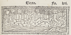
The book is open to an illustration that purports to show Brazilian
natives. This picture had a powerful influence on Europe's image of
native Americans. In fact, the illustration was drawn by a Strasbourg
artist who never saw a native American; he based his drawing on
Renaissance concepts of the ideal human body.
11.
Martin
Waldseemüller, 1470-1521?
Cosmographiae introductio cum quibusdam geometriae ac astronomiae
principiis ad eam rem necessariis . . .
Saint-Dié:
Gautier Lud, 1507.
Lilly Library call number:
E125 .V6 M15 1509 Vault
This is the book that gave the name "America" to the newly discovered
lands in the West.
In 1506, Martin Waldseemüller and
several other humanists were working together at the court of Duke
René, in the little town of Saint-Dié, in the
Vosges Mountains of northeastern France. The humanists and their patron
shared an interest in astronomy and cosmography. Together they were
compiling a world atlas based on Ptolemy's Geography.
The German humanist Matthias Ringmann joined the Saint-Dié group,
bringing his translation of Vespucci's second letter. In comparing
Vespucci's account to the works of Ptolemy, he discovered that the lands
Vespucci described related to a new world not mentioned by Ptolemy, a
world apparently lying under the Antarctic pole. Excited by this
discovery, the humanists decided to produce a world map to include the
lands not mentioned by Ptolemy.
Waldseemüller and Ringmann wrote this small tract on cosmography
to serve as an introduction to the world map as well as to their planned
atlas. It was entitled An introduction to cosmography with
several elements of geometry and astronomy required for this
science, and the four voyages of Amerigo Vespucci. In the text the
authors suggested that the new lands, which formed the fourth part of
the world, should be named "Amerigo" or "America" to honor Vespucci,
whom they believed had discovered them. The little volume was widely
distributed.
A few years later, Waldseemüller realized that these were the same lands
earlier discovered by Columbus on his third voyage. He removed the name
"America" in later editions, but by then it had become generally
accepted. Despite all the efforts by Columbus and the Spanish monarchs
to publicize Castile's discoveries and claims, the name of the Western
Hemisphere would forever belong to Vespucci, an Italian businessman who
had no role in its first exploration by Europeans.
The book is open to the Saint-Dié humanists' introduction to
Vespucci's letter, where the authors give their reason for the name
"America":
Now, really these [three] parts [Europe, Africa, and Asia]
were more widely traveled, and another fourth part was discovered by
Americus Vesputius (as will be seen in the following pages), for which
reason I do not see why anyone would reasonably object to calling it
(after the discoverer Americus, a man of wisdom and expertise)
"Amerige," that is, land of Americus, or "America," since both "Europa"
and "Asia" are names derived from women.
12.
Hernando Cortés,
1485-1547.
Praeclara Ferdinando Cortesii de noua maris oceani Hyspania
narratio . ..
Nuremberg: Friedrich Peypus,
1524.
Lilly Library call number:
F1230 .C8 1524 Vault
By 1515, Spaniards had established twenty-seven cities and towns on the
four major Caribbean Islands—Española, Cuba,
Jamaica, and Puerto Rico. They had tried to establish cities and towns
on the mainland, the east coast of which they had explored and mapped
from Brazil to southern Georgia. Yet every Spanish colony on the
mainland had been destroyed by epidemic, crop failure, or native attack.
If they were going to secure sovereignty over the mainland, they would
have to conquer the native rulers first. This means of effective
occupation became the norm in the European colonization of the Americas.
Hernando Cortés led the first successful conquest of a native
ruler on the American mainland. Leading an expedition of about four
hundred men, Cortés sailed from Cuba in 1518 and won the support of
dozens of Indian city-states that had been conquered by Moctezuma's
expanding Mexica (Aztec) empire. With the assistance of about 100,000
native warriors from these allies he had conquered Moctezuma's capital
city of Tenochtitlán (Mexico City) by 1522.
Cortés described his expedition's progress, defeats, and
victories in five long letters he sent to the new ruler of Spain,
Charles V. In his second letter, Cortés described the allied
army's march from the coast at Veracruz to the valley of Mexico,
Moctezuma's capitulation to the invading forces, and the allies'
occupation of the capital. The Spaniards, who considered cities to be
the mark of a civilized society, marveled at the sophistication and
monumentality of Mexico City. They also expressed horror and disgust at
some of the Mexica religious rites.
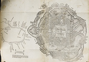
The book is open to a map of Mexico City that accompanied Cortés's
second letter to Charles V. This is the first map of any American city.
This map is also the first to contain the designation "La Florida." It
lies to the northeast of the Yucatán, Cuba, and the Panuco
River.
Within the city, we can see its canals and massive architecture,
including pyramids and ball court. We can also see the skull rack, where
the Aztecs displayed the heads of captives and hostages who had been
sacrificed in the temple of the main pyramid. In this Latin translation,
the skull rack is labeled capita sacrificatorum.
13.
Escrituras casa en la calle real, Mexico.
1527, May 9-1648, July 13.
Lilly Library:
Latin America mss. Mexico
Although the Mexica succeeded in defeating and expelling the Spaniards
and their allies from Tenochtitlán in 1520, Cortés
retreated to the allied city of Tlascala and formed a new army with
reinforcements from another Spanish expedition. This much larger force
definitively conquered the Mexica's new lord Cuauhtemoc, who had led a
heroic resistance.
Immediately after the conquest, the Spaniards occupied the land and
buildings. In order to distribute the property according to Castilian
law, Cortés carried out a survey of all the property in the
city. He took the property, tribute, and other income that had belonged
to the ruling dynasty and turned it over to the Spanish monarchy. The
properties and income of the native temples became the property of the
church. Private houses and lots in the city became the booty of the
conquerors.
This manuscript is a bill of sale for a house and its lot in Mexico City.
Cortés had given the lot to one of the conquerors, Juan
Ximénez, in 1524, and on
May 9, 1527, Ximénez sold it to
another Spaniard, Ruy Pérez, for 100.5 pesos of gold.
The manuscript is open to the 1527 bill of
sale containing the property description:
A lot that I have and own in this city [of Temistitan],
which is adjoined on one side by the property of Alonso Galeote, on the
front by the street, and in back by the property of Hernando de Xerez.
The sale included the lot, buildings, and some building stone.
14.
Antonio Pigafetta,
ca. 1480/91-ca. 1534,
and Transylvanus Maximilianus.
II viaggio fatto da gli Spaniuoli a torno a' l mondo . . .
Venice: Lucantonio Giunta,
1536.
Lilly Library call number:
G420.M2 M4 1536 Vault
In 1519, an Italian merchant from Vicenza, Antonio Pigafetta, booked
passage on a fateful voyage departing from the Spanish port of Sanlúcar
de Barrameda, bound for Asia. Portuguese fleets had been traveling
around Africa to Asia for ten years, but this expedition was different;
the Portuguese captain of this fleet of five ships, Ferdinand Magellan,
was commissioned by Spain to find a route through or around South
America in order to cross the Pacific and reach Asia.
Spaniards had no illusions that this would be an easy voyage. In 1515,
Castile had sent an expedition with this same objective under the
command of the royal pilot Juan Díaz de Solís. The Solís expedition,
after carefully exploring the coast of South America from Brazil to
Argentina, entered the Río de la Plata, where Solís was killed by
natives, and the expedition fell apart. Where Solís had failed, Magellan
succeeded, though he too was killed by natives, in the Philippines,
before completing his voyage
At the end, a Spanish seaman named Juan Sebastián de Elcano
brought the fleet back from Asia. In the Spice Islands they sold the
leaking Concepción to buy a cargo of cloves, but Trinidad's
captain and crew chose to go back across the Pacific rather than
continue west. Elcano navigated the lone surviving ship Victoria around
Africa, and arrived home in September 1522, three years after the
expedition had departed. Victoria's cargo of cloves fetched such a high
price on the market that it paid for all the expedition's expenses and
turned a handsome profit for the expedition's stockholders.
The news of this first circumnavigation of the globe spread rapidly.
Hernando Cortés heard it the same year from the captain of a Spanish
colonizing expedition he ran into on the coast of Honduras; he
immediately wrote a note of congratulations to Emperor Charles V. Yet
for all the significance of this, Spain's first voyage to the Spice
Islands, we would know very little were it not for the Italian
passenger. Pigafetta wrote an account of the voyage in which he
chronicled the terrors of the violent passage through the Straits of
Magellan, the horrors of starvation and lack of drinking water during
the Pacific crossing, and the many intrigues and betrayals once the
fleet reached Asia.
This is the first Italian translation of Pigafetta's narrative. The book
is open to the final pages, which give a brief Brazilian vocabulary.
15.
Charles V, Holy Roman Emperor, 1500-1558.
Letter to Antonio de Mendoza.
1537, Feb 16.
Lilly Library:
Latin American mss. Mexico
As Spanish explorers penetrated the interior of Mexico and moved farther
north, the monarchy delegated to the viceroy of New Spain the power to
draw up contracts, or capitulations, between the crown and the explorer.
The first viceroy of New Spain, Antonio de Mendoza, arrived at his post
in Mexico City in 1535 and immediately began regularizing the government
and extending Spain's effective occupation of the North American
continent.
A couple of years later, Emperor Charles V sent him this letter
recommending Francisco Vásquez Coronado
(1510-1554). The king reminded
his viceroy that Coronado's father and brother had both served the
Spanish monarchy and suggested that Coronado be given important
assignments that would benefit the monarchy.
Clearly, the king was approving an appointment that Mendoza had already
suggested. In 1539, the viceroy commissioned Coronado as commander of an
expedition that was being assembled to explore the present southwest
United States. The Coronado expedition, comprising 336 Spaniards,
hundreds of Indian guides and bearers, and more than 1,500 horses,
mules, and livestock, began moving north from Culiacán on April
22, 1540.
During the next two years, the Coronado expedition explored Arizona, New
Mexico, Texas, Oklahoma, and Kansas. Without being aware of it, the
expedition at one time was within seven hundred miles of the De Soto
expedition, which was exploring westward from Florida and Georgia to the
Mississippi. The Coronado expedition began its return
march to Mexico City in early April 1542, after Coronado had been
seriously injured in a riding accident. For Europeans, his explorations
transformed North America from an imaginary island into another new
continent for colonization.
16.
Leyes y ordenanças nueuame[n]te hechas por su magestad, pa[ra]
la gouernacion de las Indias y buen tratamiento y conseruacion de
los Indios: que se han de guardar en el consejo y audie[n]cias
reales q[ue] en ellas residen: y por todos los otros gouernadores
juezes y personas particulares dellas.
Alcalá de Henares: Juan de
Brocar, 1543.
Lilly Library call number:
F1411 .S73 L68 1543 Mendel
The laws that had traditionally governed Spain soon proved to be
inadequate to deal with the many new situations that arose as Spaniards
and native Americans struggled to live together. On the recommendation
of many colonists and royal officials, Emperor Charles V issued new laws
for the Americas. These laws were designed to improve the administration
of the colonies and provide a more effective judicial system.
The most controversial parts of the New Laws attempted to improve the
situation of the native Americans and eliminate colonists' control over
Indian labor. Colonists who had the most to lose objected vehemently, so
the viceroys implemented the laws gradually and piecemeal, compromising
in some situations and discarding ordinances in others. By about 1570,
three-quarters of the grants of Indian labor to private individuals had
been converted to taxes and service paid to the royal treasury. By the
end of the century, the old system of Indian labor was effectively
ended. Indians in most of Spanish America had become, like Spaniards
themselves, taxpayers to the royal government rather than forced
laborers.
17.
Juan
Ginés de Sepúlveda,
1490-1573.
Apologia Ioannis Genesii Sepulvedae pro libro de iustis belli
causis ad amplissimum, & doctissimum praesulem.
Rome: Valerio and Luigi
Dorici, 1550
Lilly Library call number:
F1411 .S47 Vault
From the beginning of the American enterprise, many Spaniards were
troubled by the moral and legal questions posed in the Americas.
Particularly vexing was the question of whether native Americans should
be allowed to continue their own life style or should be integrated into
the mores of Europeans.
Dr. Juan Ginés de Sepúlveda, eminent humanist at the
University of Salamanca and translator of Aristotle, used the reasoning
of the ancient Greek philosopher to address this question. Employing
Aristotle's theory of natural slavery, Sepúlveda argued that the
natives' political inferiority, idolatries, and other sins were in their
very nature. They were not capable of change by their own volition or by
the example of Europeans. Only by war and consequent enslavement could
barbarous customs such as idolatry, cannibalism, and human sacrifice be
ended.
Sepúlveda also based his argument on the papal decree of 1493
that divided the Spanish and Portuguese spheres of exploration. Because
the pope had granted sovereignty over the Western
Hemisphere to Spain and charged the Spanish monarchy with responsibility
for converting the natives to Christianity, Spain should end these
practices abhorrent to Christians. Conquest of the Indians was
necessary, and therefore constituted a just war.
The book is open to Sepúlveda's discussion of the papal decree
and its logical consequence, war against barbarous Indian practices in
the Americas.
18.
Bartolomé de Las Casas, 1474-1566.
Tratado co[m]probatorio del Imperio soberano y principado
universal que los reyes de Castilla y León tienen sobre las
Indias. Seville:
Sebastián Trugillo, 1553.
Lilly Library call number:
F1411 .C28 Vault
The greatest opponent of Sepúlveda's conclusions, though not
of his reasoning, was Bartolomé de Las Casas, a Dominican
friar who had lived in the Indies, where he had inherited from his
father a grant of Indian labor on the island of Cuba. Horrified by the
consequences of the Indian labor grants, Las Casas devoted most of his
life to saving the Indians from the Europeans. In order to develop his
power of argument, he studied logic and philosophy at the University of
Salamanca.
Vehemently opposed to forced conversion, and therefore to conquest, Las
Casas argued that the Indians were in an early stage of development,
just as Europeans had been millennia before. They were capable of
acquiring European culture by example and therefore should live in
settled communities in the presence of priests and other good Europeans.
In 1550 Emperor Charles V summoned jurists, including Sepúlveda and Las
Casas to debate the issue. The famous debate before the emperor in
Valladolid produced no resolution. It is important to remember that Las
Casas and Sepúlveda both wanted to achieve the same
objective—conversion of the Indians to Christianity and the
end of their barbarous practices—and that they both used
Aristotelian logic to make their arguments.
The volume contains a collection of nine tracts by Las Casas. Here, it is
open to the first tract, where, in order to lay the basis for the
reforms he was demanding, Las Casas presents proofs that Spain has
legitimate sovereignty by virtue of the papal decree of 1493.
19.
Philip II, King of Spain,
1527-1598.
Grant of liberty to the town of Tlascala.
1556, August 24.
Lilly Library:
Latin American mss. Mexico
As the conquest generation aged and passed away, the lines between Indian
and Spaniard became blurred. Spaniards and Indians married; their
children were legally considered Spaniards, regardless of race or
language. Spanish colonists and American Indians became bilingual, using
both Spanish and the dominant local Indian language. Government policy
integrated Indian communities into the Spanish political system.
Some Indian communities were particularly eager to obtain the benefits of
full political integration. Hernando Cortés had been able to conquer the
Aztec capital largely because he persuaded dozens of Indian towns to
become his allies. Among the first and most important of these allies
was the Indian town of Tlascala. After the conquest, the Spanish
government tended to treat all Indian towns alike, despite their varying
roles in the conquest. This, of course, offended and worried the
Tlascalans. They sued, protesting that their original agreement had been
violated.
In 1556, King Philip II granted this charter of liberty to the town of
Tlascala. He assured the Tlascalans that they would forever enjoy all
the freedoms, tax exemptions, and privileges of a Spanish town.
The document is open to the text issued by the royal chancery and its
translator, with matching texts in Spanish and the Aztec language,
Nahuatl.
20.
Títulos de las casas que compró
Catalina Vázquez en el barrio de Tomatlán.
1562, Oct 4-1597, Nov. 18.
Lilly Library:
Latin American mss. Mexico
Both Spaniards and Indians made full use of the judicial system to press
their claims and ask for redress of grievances. In property disputes,
the litigants submitted testimony and legal documents in both languages
and also in the pictorial tradition of Nahuatl manuscripts.
This bill of sale is written in both Spanish and Nahuatl, and the property is
sketched showing the Indian owners in residence. The owner of one house
is don Diego de San Francisco and the other is doña María Francisca.
21.
Juana de Austria 1535-1573.
V. Md. aprueba el assiento que se ha tomado con don
Francisco de Mendoça.
1558, Dec 10.
Lilly Library:
Latin American mss. Mexico
The original intention of Fernando and Isabel had been to find a western
route to Asia and its spices. In the mid-sixteenth century, the Spanish
monarchs were still trying to enter the spice trade. In Francisco de
Mendoza they thought they had found the ideal spice producer. Mendoza
had gone to New Spain (modern Mexico) as a teenager with his father,
Antonio de Mendoza, the first viceroy. For twenty years, Francisco
assisted his father and engaged in business.
After his father's death, Francisco returned to Spain. He was looking for
a profitable investment for the silver he had brought back, both for
himself and for other colonists who had made their fortunes in the
Americas. The American investors thought that Francisco would be the
ideal investment manager in Spain; his relatives were among the most
powerful nobles at court.
In this royal concession, Princess Juana
granted Francisco a monopoly on the planting and marketing of Asian
spices—Chinese ginger and sandalwood—in New Spain.
In return for land, a sufficient number of Indian laborers, and start-
up tax exemptions, Francisco agreed to pay the monarchy
one-half of all the profits on his spice sales.
All of this came to nothing, however. A few weeks later, the princess
commissioned Francisco to inspect all the mines in Spain and recommend
which ones the monarchy should develop. Once Francisco had completed
this assignment, the king appointed him director of the royal mines, and
he spent the rest of his life in the royal service in Spain. He never
went back to New Spain. Other Spaniards took up the project, however,
and a century later ginger had become one of the leading cash crops of
the town of Coamo in Puerto Rico.
The last page of the manuscript displays the signatures and rubrics of
all the officials who signed off on this contract, including the
princess and the king.
22.
Richard
Hakluyt, 1552-1616. The principall navigations, voiages and
discoveries of the English nation, made by sea or ouer land . . . .
London: George Bishop and Ralph
Newberie, 1589.
Lilly Library call number:
G240 .H14 1589 Vault
While the Spanish monarchy sponsored dozens of expeditions of exploration
by sea and land and Spanish colonists founded and settled more than a
hundred cities and towns in the Americas, the English made no effort to
establish their presence in the New World. English fishing fleets, along
with ships from Portugal, Spain, France, and Scandinavia, made seasonal
trips to the fishing banks of North America, drying and salting their
catch onshore and then carrying their cargo back to Europe in time for
the Lenten season. The French king Francis I made several unsuccessful
attempts to claim and settle parts of North America and Brazil, but in
England neither the queen nor Parliament regarded the Americas as an
important objective of royal policy; they were busy conquering and
colonizing Ireland.
One Englishman and his son, both named Richard Hakluyt, had very
different ideas. They had the mentality of the space race in modern
times and began publicizing their views with Parliament and the royal
court. They convinced Sir Humphrey Gilbert and, after Sir Humphrey's
death, his half-brother Sir Walter Raleigh that England should challenge
Spanish sovereignty over North America by establishing effective
occupation. Sir Walter organized and financed a colonizing voyage, which
established a short-lived settlement on Roanoke Island, Virginia.
Despite the failure of the Roanoke venture, Hakluyt remained convinced
that the English should colonize North America. In order to publicize
this idea and bring pressure on the royal government and Parliament,
Hakluyt began publishing narratives of early voyages to North America.
For the foreign voyages, he commissioned translations into English, but
his principal objective was to use the early English voyages as a legal
basis for English sovereignty in North America. Hakluyt's efforts bore
fruit in the seventeenth century, when England was devastated by
religious persecution and civil war. Hundreds of thousands of English
people fleeing the turmoil and dangers of their own country turned to
Hakluyt's narratives and, believing his rosy picture of America,
emigrated to Virginia and New England.
Publication of these narratives of exploration in English translation
continues to the present day, under the title Hakluyt's Voyages.
23.
Francisco Fernández de la
Cueva Enríquez,
d. 1733, et. al.
Documents concerning the sending of twelve Indian families to
Florida.
1703, Sept. 11-1704, Apr. 5.
Lilly Library:
Latin America mss. Mexico
With English settlers moving into Virginia and Georgia and making
incursions into Florida, the Spanish government wanted to encourage
Spanish colonies in North America. Those in Florida were particularly
important because they secured the coast along the major route for the
return voyage of the annual silver fleets.
The government decided to use a method that had developed in other
frontier colonizations. Traditionally, Spaniards and Indians from
already-colonized regions went to settle the northern frontier. The
colonists who settled New Mexico in the late sixteenth century, for
example, came mostly from the silver mining towns of northern Mexico.
This time, the viceroy of New Spain, the duke of Albuquerque, found
Indians from New Spain who were willing to emigrate to Florida. The
manuscript is open to the first page of the viceroy's decree authorizing
twelve Tlascalan families to colonize Florida. The signature reads
"Duque de Albuquerque."
24.
Ulrich von Hutten, 1488-1523. Of the wood called guaiacum, that
healeth the frenche pockes, and also helpeth the goute in the feete,
the stone, palsey, lepre, dropsy, fallynge euyll, and other diseses.
Made in Latyn by Ulrich Hutten, knyght, and translated in to Englysh
by Thomas Paynel. London:
Thomas Berthelet, 1540.
Lilly Library call number:
R520.6 .H9 1540 Vault
With the Atlantic transformed from obstacle to conduit, people, plants,
and animals moved back and forth between Europe and America for the
first time. Species that had existed only on one side of the Atlantic
now became common on both sides, a process we now call the Columbian
Exchange.
One of the negative effects of the Columbian Exchange devastated native
American cultures; disease-bearing microorganisms from Europe infected
hundreds of thousands of American Indians. Diseases such as measles,
typhus, and small pox had not existed in the Americas, and when the
indigenous population was first exposed, they all got sick at once. When
most of a community is seriously ill at the same time, there is no one
to care for the sick. People who might have survived with adequate
drinking water, food, and clean conditions died of dehydration and
secondary infections.
Only one disease, syphilis, traveled in the opposite direction. There now
seems little doubt that syphilis was in the Americas prior to 1492 and
came to Europe on Columbus's return in 1493. Most Europeans called it
the "French disease," because the first cases appeared in the French
army that invaded Italy in 1494.
By 1500, syphilis had become an epidemic, spreading rapidly throughout
Europe in a pattern characteristic of a new venereal disease in a
population having no prior immunity.
Diagnoses and treatments were suggested by many physicians, including the
Italian Girolamo Fracastoro and the Spaniard Pedro Mexía (who called it
the "Indies disease"). The afflicted desperately sought any concoction
that might give relief from the painful and disfiguring symptoms, even
when the treatment was as bad as the disease. A German knight who was
infected with the disease, Ulrich von Hutten, published this treatise
advocating the use of guaiacum, the extract of an American wood. The
book was immediately popular throughout Europe and appeared in English
translation in 1540.
25.
Nicolás Monardes, ca. 1512-1588.
Primera y segunda y tercera partes de la historia medicinal de
las cosas que se traen de nuestras Indias Occidentales que sirven en
medicina.
Seville
Alonso Escrivano, 1574.
Lilly Library call number:
RS169 .M5 1574 Vault
26.
Nicolás Monardes, ca. 1512-1588.
De simplicibus medicamentis ex occidentali India delatis, quorum
in medicina usus est . . .
Antwerp: Christophe Plantin,
1574.
Lilly Library call number:
RS169 .M56 1574
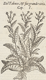
This Antwerp edition of Monardes's book on the medicinal uses of American
plants is open to his discussion of tobacco as a medicine.
27.
Nicolás Monardes, ca. 1512-1588.
Delle cose che vengono portate dall'Indie occidentali pertinenti
al'uso della medicina.
Venice: Giordan Ziletti,
1582.
Lilly Library call number:
RS169 .M55 1582
28.
Gonzalo Fernández de Oviedo y Valdés, 1478-1557.
La historia general de las Indias.
Seville: Juan Cromberger,
1535.
In the first century of colonization, Europeans who stayed at home wanted
to know the ways that native American societies were different from
their own. Consequently, colonial writers filled their books with
descriptions and illustrations of every aspect of native America that
was unknown in Europe. When colonial writers did not describe some
aspect of Indian society, we can safely assume that it was considered
too similar to Europe to warrant mention.
Gonzalo Fernández de Oviedo spent most of his life in the
Americas as a royal inspector of mines and as commander of the fortress
at Santo Domingo. Fascinated by the local customs and the exploits of
the Spanish conquerors, Oviedo recorded his observations of native
customs, artifacts, flora, fauna, and language, and he interviewed
participants in Spanish expeditions to the American mainlands.
An incurable reviser of his own work, even after publication, he
composed, expanded, and rewrote his books on board ship during his
thirteen transatlantic voyages. To him we owe much of what we know of
Indian words, customs, and skills.
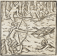
In his second book, On the general and natural history of the Indies,
Oviedo described how the islanders made their dugout canoes, even though
they had no metal tools to work with:
On this island of Española and in all other coasts and rivers of the
Indies that Christians have seen up to now, there is one type of
boat, which the Indians call 'canoe.' With these they navigate the
great rivers as well as the oceans for purposes of war and raid, for
conducting commerce between one island and another, or for fishing
and other purposes. Without these canoes, we Christians who live
here could not benefit from our property on the coasts and
riverbanks.
Each canoe is a single branch or tree trunk, which the Indians hollow
with blows of stone-headed axes, like the one illustrated here. With
these they cut or scrape the wood to hollow it. Then they burn what
has been beaten and cut little by little. When the fire goes out,
they again cut and beat it, alternating these two processes until
the boat is formed to the limits of the width and length of the tree
trunk.
I've seen them large enough to carry forty-five men, wide enough to
hold a wine cask easily between the Carib Indian archers. The Caribs
use them as large as I have mentioned and call them pirogues,
navigating with cotton sails and by oar, as well as with their
paddles, as they call their oars. Sometimes they paddle standing, at
times sitting, and kneeling when they feel like it.
Some of these canoes are so small that they hold no more than two or
three Indians, others hold six, others ten, and on up. But no matter
what size, they are very light and dangerous, for they overturn
frequently. But they don't sink even when they are immersed. And
because these Indians are great swimmers, they turn them upright and
smartly empty them .... They are safer than our ships in case of
capsizing. Even though ours capsize less often because they are more
flexible and buoyant, once they are immersed they sink to the
bottom.
29.
Gonzalo Fernández de Oviedo y Valdés, 1478-1557.
Coronica de las Indias. Salamanca:
Juan de Junta, 1547.
Lilly Library call number:
E141 .O89 1547 Vault
30.
Gonzalo Fernández de Oviedo y Valdés, 1478-1557.
L'histoire naturelle et generalle des Indes, isles, et terre
ferme de la grand mer oceane. Paris:
Michel de Vascosan, 1555.
Lilly Library call number:
E141 .O893 1555
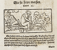
Oviedo was fascinated by the techniques American Indians had developed
for familiar tasks, such as preparing food, building houses, and
manufacturing tools and equipment. Here he illustrates the Indian method
of starting a fire without the flint and steel that Europeans required.
The native Americans rotated a stick poised on a piece of wood by
rubbing the stick between their hands to create heat.
31.
Denis le Chartreux.
Este es un compendio breue que tracta d'la manera de como se
han de hazer las processiones. Mexico
City: Juan Cromberger, 1544.
Lilly Library call number:
BX2324 .M6 D39 Vault
In 1539, the first printing press arrived in the Americas. It was
established in Mexico City as a branch of the Seville press owned by the
Cromberger family. Juan Cromberger in Mexico followed the same policies
he had learned in the family firm in Seville. In Europe, printing had
been a business from the beginning. Most printers were motivated by
profit and they tended to reproduce those texts that had already been
most in demand before the advent of printing.
Denis the Carthusian's little book on how to lead a Christian life had
been a Latin classic for two centuries when the new bishop of Mexico,
Juan de Zumárraga, commissioned this printing of Denis's
section on processions, in Spanish translation.
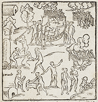
Clearly, the good bishop thought that Spanish colonists in America were
behaving no better than their medieval predecessors in Europe. The
section that he commissioned from Cromberger points out the behaviors
that are not suitable for holy processions: foolishness, pompous attire,
drinks inappropriate to the time and place, and above all buffoonery and
other lewd acts that provoke carnal sins.
32.
Francisco López de Gómara, 1510-1560?.
La istoria de las Indias y conquista de Mexico.
Saragossa: Agustín
Millán, 1552.
Lilly Library call number:
E141 .G5 1552 Mendel Vault
The secretary of Hernando Cortés, Francisco López
de Gómara, never saw America, yet he made excellent use of
reports and descriptions from members of the Cortés expedition. Gómara
devotes three chapters to Aztec women, focusing on practices that surely
would arouse the curiosity of Europeans; how women are buried, the
practice of polygamy, and marriage rites.
The book is open to a description of the Aztec writing and number systems
and the names of the months and days in the Aztec calendar.
33.
Pedro de Cieza de León, 1518-1560. Parte
primera de la chronica del Peru.
Seville: Martin de
Montesdoca, 1553.
Lilly Library call number:
F3442 .C29 Mendel Vault
34.
Hans Staden. Warhaftig Historia un Beschreibung eyner
Landtschafft der Wilden.
Marburg: Andreas Kolbe, 1557.
Lilly Library call number:
F2528 .S74 Vault
35.
Domingo de
Santo Tomás, 1499-1570. Grammatica, ò
arte de la lengua general de los indios de los reynos del Peru.
Valladolid: Francisco
Fernández de Códova, 1560.
Lilly Library call number:
PM6303 .D6 1560 Vault
36.
Doctrina Christiana y catecismo para instruccion de los
indios. Lima: Antonio
Ricardo, 1584.
Lilly Library call number:
PM6308.1 .D63 Vault
In contrast to the earlier Cromberger book in Mexico City, which was aimed at
laymen, this little book was intended as a manual for priests. The Spanish
priests in Peru already knew how to speak the native languages. In 1583,
they came from all over Peru, meeting in the Spanish capital, Ciudad de los
Reyes [Lima]. They translated the Catholic catechism into the two principal
native languages of Peru, Kechua, and Aymara, and commissioned this printing
from the press of Antonio Ricardo.
The catechism had been invented by Martin Luther, but Catholics soon compiled
their own. In Europe, children were required to memorize the fundamentals of
the Christian faith, in the form of prayers, the creed, and
question-and-answer sequences. The book is open to the first prayers that
every Catholic child learned, the "Lord's Prayer" and "Hail Mary." Here the
prayers in Spanish are followed by their translations into Kechua in the
left column and Aymara in the right column.
37.
Giovanni Battista
Ramusio, 1485-1557.
Terzo volume delle navigationi et viaggi.
Venice: Giunti, 1565.
Lilly Library call number:
G159 .R2 v. 3 1565
38.
Jean de Léry,
1534-1611.
Historia navigationis in Brasiliam quae et America dicitur.
Geneva: Heirs of Eustache
Vignon, 1594.
Lilly Library call number:
F2511 .L66 1594
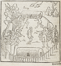
Jean de Léry recorded the history of an attempted French
settlement in Brazil in the mid-sixteenth century. The settlement failed
largely because of conflict among the colonists and hostility of the native
Americans. Léry found much to comment on in the exotic flora and fauna. He
provided careful drawings of Indian customs and regalia, and the publisher's
woodblock cutter transformed the Indians into classic beauties in the poses
of Greek gods. Here, he illustrates Indians dancing in feather headdress,
using a gourd shaker, with a monkey in the foreground and a parrot in the
background. On the facing page, Léry provides an example of an
Indian chant.
Discovering the Earth's Surface
Maps and Navigation
Europeans from the most ancient times had known that the world was a sphere, but none had ever imagined that a continent separated
Asia from Europe. The Columbian voyages, especially the third voyage that explored the coast of Venezuela
in 1498, revolutionized
European concepts of geography and provided new data for the science of navigation.
As they acquired new information by exploring the Americas, pilots, map-makers, and scientists over the next century were
able to
improve estimates of the earth's circumference, determine the true extent of the earth's land masses and
oceans, and establish the
longitude and latitude of most ports and cities all over the globe.
Changes did not come easily. Instruments were rudimentary and timepieces unreliable. Navigators who achieved splendid practical
results by dead reckoning also made and recorded celestial observations that were wildly inaccurate.
The Portuguese king
insisted that his captains use an erroneous method of determining longitude. Many publishers did not
bother to update maps
when they issued new editions.
Columbus and other captains depended on experienced pilots who conducted their Spanish voyages to the Americas by dead
reckoning.
Working from route charts, they took advantage of wind and sea currents in the Atlantic and drew on their
years of experience at
sea to calculate fairly accurately the north-south distance (latitude) traveled. Longitude was more difficult
to estimate.
Nevertheless, by the year 1500, dozens of Spanish voyages had traveled safely to and from the Western Hemisphere, piloted by men
like Juan Aguado, Columbus and his brother Bartolomé Colón, Juan de La Cosa, Alonso de Hojeda, Andrés
de Morales,
Peralonso Niño, Vicente Yáñez Pinzón, Bartolomé Roldán, Alonso de Torres, and Juan de Umbría.
These were just some of the better-known pilots and navigators. There were many, many more.
In the beginning of transatlantic navigation, few records were made public. Ship's logs were not kept until the sixteenth
century—
Columbus's diary from his first voyage being the great exception. A few Portuguese pilots kept records
that they turned over to
their king for inclusion in the royal cosmographical charts and tables. But these charts were state secrets
not shared with other
nations. As a result, we know very little of how any one of these voyages was navigated.
Despite this policy of secrecy, the published works displayed here indicate great changes in methods of navigation. The first
changes made celestial navigation practical for seafaring. For centuries, land travelers in desert
regions had observed the
stars. Like seafarers, desert travelers had no landmarks by which to orient themselves, and a sophisticated
science of celestial
navigation had been developed by Arab scientists. Celestial observations were extremely difficult at
sea, however, and the
Atlantic offered no handy islands along the way to take
steady, accurate readings. To overcome these difficulties, Spanish and Portuguese pilots and mathematicians
invented new instruments
for observations, improved old ones, added new data from the Southern and Western Hemispheres, and compiled
tables of altitude,
longitude, and latitude. Increasingly, seamen made use of celestial navigation in transatlantic voyages,
although dead reckoning
remained essential until the modern development of accurate and reliable timepieces.
In order to define their position on the earth's surface in circular measure, seamen needed a common set of coordinates for
longitude and latitude. The method for measuring latitude from the altitude of the sun or a circumpolar
star at meridian
altitude was developed during the fifteenth century.
Longitude, however, proved much more difficult to calculate. Since ancient times, scientists understood that the earth's
rotation is synonymous with time. Longitude could be measured by timing an astronomical event, such
as an eclipse or the
conjunction of planets, that could be seen simultaneously by observers in different places. By extrapolating
from the time
difference, they could estimate the distance separating them. Arab mathematicians in Spain, in fact,
had drawn up tables
showing the positions of a heavenly body at regular intervals in time when observed from Toledo, so
that they could be used in
other places.
The problem was that the timepieces of the day were not reliable enough to calculate time accurately. The rate of the earth's
rotation is such that one degree of longitude corresponds to four minutes of time. By the year 1500 the best mechanical clocks
were subject to an error of about ten minutes a day. Columbus tried to determine longitude by observation
of eclipses while at
anchor in the Caribbean in 1494 and 1504 using published tables.
He miscalculated the true longitude in 1494 by 22°30'; in 1504 by 38'.
With errors of this magnitude common, celestial navigation was not practical. The tables and instruments were not adequate
for
navigation or cartography. In Portuguese and Spanish Attempts to Measure Longitude in the 16th Century,
W. G. L. Randles notes that the Portuguese king ordered pilots to use an erroneous master chart of the
route to India on
which longitudes had been determined by lunar and solar eclipses. The result had been shipwrecks. Portuguese
pilots
therefore had their charts made secretly in Spain, using traditional methods.
39.
Laurentius Corvinus,
1465?-1527.
Cosmographia dans manuductionem in tabulas
Ptholomaei . . . Basel: Nikolaus
Kessler, 1496.
Lilly Library call number:
G87 .P97 C8 1496 Vault
The Geography of Ptolemy, originally written in the second century, was
not known during most of the Middle Ages. A Byzantine monk, Maximus
Planudes, (ca. 1260-1310) discovered a copy of
the Geography in 1295. It had no maps, so he reconstructed
them from the coordinates in the text. In 1405, the Florentine humanist Jacobus Angelus
made the first Latin translation and changed the title to
Cosmography.
Ptolemy's organization of his work into eight books became the model for
all geographies for centuries after the Latin translation first
appeared. In Book 1, Ptolemy stated his objectives: to give coordinates
of places and geographical features and make recommendations for
creating a world map and regional maps. The remainder of the book gives
names and coordinates for all the oikumene (known world): Books 2 and 3
cover Europe; Book 4, Africa; Books 5 through 8, Asia and a summary.
Though the map (if it ever existed) did not survive, the text provided
tools essential for drawing one: a system of coordinates based on
longitude and latitude, instructions for making rigorous maps, and a
critical scientific attitude.
Laurentius Corvinus edited Ptolemy's Geography, collating
the Greek place names with Latin place names. Like all editors of the
Geography, he was tantalized by Ptolemy's list of
place names from ancient texts whose locations were not
known—the Terrae incognitae.
40.
Pomponius Mela,
fl. 43-50.
Cosmographia pomponii cum figuris.
Salamanca: 1498.
Lilly Library call number:
G87 .M48 1498 Vault
Despite the official policy of keeping navigational information secret,
scientific curiosity about the newly explored territory was so intense
that scholars managed to piece together reports from ship's officers and
integrate the information into new views of the earth.
The cosmographical treatise by the ancient writer Pomponius Mela was a
popular textbook for undergraduates at the University of Salamanca in
the late fifteenth century. This edition by Francisco
Núñez de la Yerva, professor of medicine at the
university, placed emphasis on teaching students the longitude and
latitude of Europe's large cities and ports. The didactic tone of the
edition is so intense that, on the title page, Núñez gives the
longitude and latitude of Salamanca, where the book was printed:
cuius loci elongatio ab occidenti. IX & ab
equinoctiali xlj. gradibus constat.
The book is open to the
famous first Spanish world map. The map is a graduated planisphere
showing longitude and latitude of the major ports and cities.
41.
Gregor
Reisch, d. 1525. Margarita
philosophica. Freiburg:
Johann Schott, 1503.
Lilly Library call number:
AE3 .R375 1503
Gregor Reisch published this compendium of information about all parts of
the world ten years after news of Columbus's first voyage was published
throughout Europe.
The world map included in Reisch's encyclopedia shows many Chinas
(Sinarum Regio, Sinarum Gangeticus, Sinus Persicus, Sinus Arabicus,
Sinus Hisperioris) and many Indies (India Indus, India Intra Gangem
Fluvium o Bragma, India Extra Gangem Fluvium). Reisch labels the areas
south of India as "Extra Gangem Fluvium" and north of Scithia [modern
Siberia] as lands of cannibals (Anthropophagis).
Reisch's world map does not show Columbus's Indies, but some scholars
believe that a legend at the bottom of the map may refer to the New
World: "Here is not land but sea, in which are many unknown islands,
according to Ptolemy."
42.
Jan Glogowczyk, 1445-1507.
Introductorium compendiosum in Tractatum Spere materialis
magistri Joannis de Sacrobusto . . . per magistrum Joannem
Glogoulensem . . . Crakow: 1506.
Lilly Library call number:
QB41. G56
This is the earliest printing of a small work that was to assume great
importance in the history of early nautical astronomy, De sphaera
mundi. It was written in the early thirteenth century by the
Englishman Johannes de Sacrobosco, or John of Holywood, probably as an
introduction to a more advanced course on astronomy and cosmology. It
became a standard text during the age of discovery.
The treatise is based largely on the work of the great Arab astronomer
Alfraganus (Al Farghani, d. 861) and presents the Ptolemaic system as
put forward in Alfraganus's Almagest. It gives proofs of
the sphericity of the earth; it defines astronomical and terrestrial
terms such as the ecliptic, equator, small and great circles, meridians,
astronomical coordinates, and the twelve signs of the zodiac; and it
explains various astronomical phenomena, such as eclipses.
It was Alfraganus whose calculation of the degree of the
meridian—56 ⅔ miles—so misled Columbus,
who failed to take into account the difference between the Arabic and
the Italian mile.
43.
Fracanzano
da Montalboddo.
Paesi nouamente retrouati. Et nouo
mondo da Alberico Vesputio Florentino intitulato.
Vincenza: H. and G. M. de Sancto
Ursio, 1507.
Lilly Library call number:
E101 .F8 1507 Vault
After his short sojourn in Portugal, Amerigo Vespucci returned
to Spain, became a Castilian citizen, and was appointed to the new post
of Pilot Major. The Pilot Major's job was to maintain and update the
master sailing chart for Castile, to certify pilots, and to inspect
nautical instruments for accuracy.
Vespucci's appointment to this office is something of a puzzle.
Christopher Columbus recommended Vespucci to Queen Isabel as an
experienced business agent and ship's chandler. Vespucci, as far as we
know, never piloted a ship. Long before he became Pilot Major in
August 1508, dozens of Spanish pilots had already
navigated successful voyages to and from the Americas. There were plenty
of competent pilots and navigators available to the crown of Castile.
King Fernando probably had mixed motives for appointing him; Vespucci
claimed to have solved the problem of determining longitude, and if the
king did not keep him happy in Castile, Vespucci might sell information
about Spanish explorations and sailing charts to the Portuguese.
The book is open to an illustration for finding the altitude of Canopus
from two different positions. A first-magnitude star in the
constellation Carina, Canopus is the second brightest star in the
heavens.
44.
Martin Waldseemüller, 1470-1521?
Cosmographiae introductio com quibusdam geometriae ac
astronomiae principiis ad eam rem necessariis Insuper quattuor
Americi Vespucij nauigationes. Saint
Dié: Gautier Lud, 1507.
Lilly Library call number:
E125 .V6 W15 1507
Vault
With Columbus's voyage, mariners and scholars realized that Ptolemy's
text, and consequently the maps that had been drawn from it, contained
many gaps and errors. Ptolemy made the earth too small, treated the
Indian Ocean as closed, omitted sub-Saharan Africa, and was ignorant of
the Americas.
In their introduction to their planned world map, Waldseemüller
and his colleagues note the new continent, which they label America
because they mistakenly thought Amerigo Vespucci was the first to
describe it.
45.
Fracanzano
da Montalboddo.
Itinerarium Portugale[n]siu[m].
Milan: Joannes Angeles
Scinzeler, 1508.
Lilly Library call number:
E101 .F8 1508 Vault
In light of Portuguese explorations, Fracanzano published a map of Africa
in which the continent is accurately shaped and fully rounded, though
India and the rest of Asia remain vague and malformed.
46.
Claudius Ptolemaeus, fl.
127-151. Geographia. Rome:
Bernardino dei Vitali, 1508.
Lilly Library call number:
G1005 1508 Mendel Vault Flat
Early in the age of discovery, geographers found a way to correct
Ptolemy's errors without altering his text; they included updated tables
of longitude and latitude for many places not known to Ptolemy. For
example, Columbus's discoveries were added to the updated maps.
This reprinting of the 1507 edition has added a
world map by Johan Ruysch and an appendix by Marco of Benevento. The
list of place names with their latitudes and longitudes has grown to
thirty-six folios. Ruysch labeled American sites with the names Columbus
had given them.
47.
Martin Waldseemüller, 1470-1521?.
Cosmographie introductio.
Strasbourg: Johann
Grüninger, 1509.
Lilly Library call number:
E125 .V6 W15 1509 Vault
The treatise on cosmography, which Martin Waldseemüller and
Matthias Ringmann wrote as an introduction to a planned world map, was
one of the earliest to incorporate information about the Western
Hemisphere. This little book became very popular and went
through several editions after it first appeared in Saint-Dié
in 1507. Two private citizens of the city of
Strasbourg published this new edition in 1509.
The earth is depicted in a cordiform (heart-shaped) image and marked in
degrees of latitude and longitude. The two parts of the recently
discovered American continents are separated by a strait, with the
western coast depicted for the first time but without delineation.
48.
Pietro Martire
d'Anghiera, 1435-1526.
. . .
Opera legatio babylonica occeani
decas poemata epigrammata. Seville:
Jacobus Croumberger, 1511.
Lilly Library call number:
E141 .A6 1511 Vault
49.
Claudius Ptolemaeus, fl.
127-151. Geographia.
Venice: Jacopo Pencio,
1511.
Lilly Library call number:
G1005 1511 Vault Flat
50.
Claudius Ptolemaeus, fl.
127-151. Geographia.
Strasbourg: Johann Schott,
1513.
Lilly Library call number:
G1005 1513 Mendel
Vault Flat
This edition was prepared by Martin Waldseemüller, Matthias
Ringmann (Philesius), Essler, and Uebelin. The text includes letters by
Pico della Mirandola, Essler, Uebelin, and Giraldi
(Ziraldus).
After completing the Cosmography, making wood-block gores
for a globe, and printing the sea chart and the world map, the humanists
at Saint-Dié resumed work on their long-delayed edition of
Ptolemy's atlas, to be entitled The geographical work of Claudius
Ptolemy, the man of Alexandria, a most erudite philosopher of
mathematical learning, closely reprinted by reproduction of the Greek
originals. In order to resolve disparities in place names and textual
content, the scholars turned to other manuscript and printed copies of
Ptolemy's atlas. The classical scholar Matthias Ringmann translated
place names and texts from Greek to Latin. Waldseemüller
designed the maps.
This is the book that gave the name America to the newly discovered lands
in the West. It includes Vespucci's letter to Piero Soderini, dated from
Lisbon on 4 September 1504, in which he
describes all four of the voyages he claimed to have made.
The book is open to one of forty-five double maps that Waldseemüller
designed for this edition.
51.
Martin Waldseemüller, 1470-1521?
Cosmographiae introductio cum quibusdam geometriae ac
astronomiae principiis ad eam dem necessariis.
Lyons: Jean de La Place,
1517-1518?
Lilly Library call number:
E125 .V6 W15 1517 Vault
During the ten years after their first publication in
Saint-Dié, Waldseemüller and his colleagues accumulated much
additional information about the Spanish and Portuguese voyages of
discovery. They revised some of their earlier misconceptions, realizing,
for example, that the lands discovered by Columbus and those reported by
Vespucci were the same.
On the South American continent, they deleted the name "America" and
inserted the labels "Brazil, land of parrots," and "all of this province
was discovered by mandate of the king of Castile." They also deleted the
strait between the two American mainlands.
Although only one set of the revised world map survives, the new
information was incorporated into the Cosmography's navigational
information in later editions. This 1517-1518 edition from Lyons is open to a chart for
calculating position.
52.
Pomponius Mela,
fl. 43-50.
De orbis situ libri tres . . .
Basel: Andreas Cratander,
1522.
Lilly Library call number:
G87 .M48 1522
Wishful thinking continued to dominate map making outside the Iberian
Peninsula. In this edition of Pomponius Mela's geography, the publisher
in Basel added a foldout map displaying a fictitious strait through the
Isthmus of Panama.
53.
Marco
Polo, 1254-1323.
Cosmographia breue introdutoria en
el libro de Marco Paulo. El libro d'l famoso Marco Paulo Veneciano
d'las cosas marauillosas que vido en las partes orientales. Conuiene
saber en las Indias. Armenia. Arabia. Persia & Tartaria. E
del poderio del gran Can y otros reyes. Con otro tratado de Micer
Pogio Florentino que trata de las mesmas tierras &
yslas. Seville: Juan
Varela, 1518.
Lilly Library call number:
G370 .P7 1518 Vault
Just as the ancient geographers Ptolemy and Pomponius Mela continued to
command respect, despite their obvious gaps and errors, the medieval
merchant explorer Marco Polo enjoyed a resurgence of popularity. Italian
humanists such as Paolo dal Pozzo Toscanelli and Poggio Bracciolini
attempted to draw geographical conclusions from Polo's descriptions of
Asia. This led to misconceptions—and momentous consequences.
Toscanelli, for example, read Marco Polo's description and interpreted it
to mean that China extended much farther into the ocean than is the
case, and that Japan lay one thousand miles from the Chinese coast.
Convinced that most of the globe's surface was covered with land rather
than water, Toscanelli had, in 1474, mistakenly informed the Portuguese
king that only 8,125 miles separated Lisbon from the east coast of Asia.
He also assured the Portuguese king that Japan and other Asian islands
were handily close for resupply on a westward voyage.
Christopher Columbus got hold of a copy of this letter, and he believed
it. It formed the basis for his early proposals for a westward voyage to
Asia, proposals that were rejected by scientific commissions in Portugal
and Spain. Even after Columbus explored the coast of Venezuela in 1498
and concluded that it was a heretofore unknown continent, he
reinterpreted Marco Polo to turn this obstacle into an incentive. If he
could find a strait around this new continent, which he tried to do on
his fourth voyage, the distance he would have to travel between its west
coast and Asia would be all the shorter.
This hope for a small ocean between South America and China gained
credence with every new publication of Marco Polo's work, because his
own estimate of the distance between China and Japan was even
greater—fifteen hundred miles. Such optimistic estimates were the
navigational foundation on which the Magellan expedition was planned,
outfitted, and provisioned, with tragic consequences when the fleet had
to cross a Pacific Ocean thousands of miles wider than anticipated.
The book is open to the title page, with woodcut illustrations of Marco
Polo, Poggio, Santo Domingo, and Calicut—the commercial port
on the southwest coast of India that had been the ultimate objective of
Columbus and the Portuguese.
54.
Hernando
Cortés, 1485-1547.
La preclara narratione di Ferdinando Córtese . . .
Venice: Bernardinus
Vercellensis, 1524.
Lilly Library call number:
F1230 .C8 1524b Vault
55.
Simon Grynaeus,
1493-1541.
Novus orbis regionum.
Basel: Johann Herwagen,
1532.
Lilly Library call number:
E141 .N9 1532
Vault
Maps and geographies have always depended on the talents and expertise of
specialists in many fields. This book was edited by Simon Grynaeus from
data collected by Johann Huttich. The emphasis in the text is on
Huttich's calculations of longitude and latitude. Unfortunately, they
did not take into account the new information brought back by Spanish
explorers. Their map of North and South America shows the two continents
separated by a strait, and the east coasts of North and South America
are crude in comparison with earlier printed maps.
56.
Claudius Ptolemaeus,
fl. 127-151.
Geographia. Basel:
Heinrich Petri, 1542.
Lilly Library call number:
G1005 1542
By 1542, much of the American coastline had been accurately mapped. Here,
although the cartographer has rendered the shapes of North and South
America more accurately than in earlier editions, there are still many
gaps and errors.
57.
Claudius Ptolemaeus,
fl. 127-151.
Geographia. Basel:
Heinrich Petri, 1545.
Lilly Library call number:
G1005 1545
Cartographers updated the maps of individual countries from one edition
to another of the Geographia, but the original version of Ruysch's world
map continued to be in use long after new information had made it
obsolete.
58.
Claudius Ptolemaeus, fl.
127-151.
Geographia. Venice:
Nicoló de Bascarini, 1548.
Lilly Library call number:
G1005 1548
In this Venetian edition of Ptolemy's Geography, the publishers have
included updated instructions and a chart to show "how it is possible to
describe the world in two dimensions as accurately as if it were drawn
on a sphere." Ptolemy's instructions are for a cylindrical projection,
which could not preserve the true angular relationships between places.
Navigators who tried to steer a course measured on this type of
projection were forced to make constant corrections in order to be
assured of a reasonably accurate landfall.
59.
Johannes Honter, 1498-1549.
Rudimentorum cosmographicorum.
Zurich: Christoph
Froschauer, 1549.
Lilly Library call number:
G113 .H7 1549
For the convenience of travelers, Johannes Honter published his Rudiments
of Cosmography in pocketbook size. His world map is in cordiform
projection to accommodate longitude and latitude, and, still using
outdated information, he shows a strait through Panama.
60.
Henricus Glareanus, 1488-1563. De geographia.
Venice: Pietro, Giovanni, Maria, and
Cornelio dei Nicolini da Sabbio, 1549.
Lilly Library call number:
GA6 .G54 1549
This geography lagged even farther behind in its knowledge of place names
and coordinates. Although the author entitled his final chapter "On the
regions not in Ptolemy," he describes America as consisting of two
islands, "Spanolla" and "Isabella."
61.
Sebastian Münster, 1439-1552.
Cosmographiae universalis. Basel:
Heinrich Petri, 1550.
Lilly Library call number:
G113. M7 1550 Vault
The Basel scholar Sebastian Münster's Universal
Cosmography assembled maps, images of cities, and
descriptions of lands and peoples of the world, including the Americas
as well as Asia and Europe. The book was a best seller, although Münster
did not discard the old to accommodate the new.
The book is open to his "Map of the New Islands." South America is
labeled "The New World," yet it is treated as part of Asia.
62.
Francisco López de Gómara, 1510-1560?.
. . . Historia general de las Indias con todo el descubrimiento y
cosas notables que han acaecido dende que se ganaron ata el
año de 1551. Con la co[n]quista
de Mexico y de la nueua España.
Zaragoza: Agustín
Millán, 1553.
Lilly Library call number:
E141 .G52 1554
Spaniards never forgot that their original intention had been to find a
westward route to Asia. This 1553 edition of
Gómara's history of Mexico includes up-to-date maps of North
and South America, as well as a map showing the principal stops along
the commercial route from Europe, around Africa, to Asia: San Lorenzo,
the Red Sea, Calicut, Ceylon, Malacca, Sumatra, Borneo, the Moluccas,
and China.
63.
Pedro de Medina, 1493-1576.
Arte de navegar en que se contienen todas las reglas,
declaraciones, secretos, y avisos, que a la buenanauegacion son
necessarios, y se deuen saber, hecha por el maestro Pedro
de Medina. Valladolid:
Francisco Fernández de
Córdova, 1545.
Lilly Library call number:
VK 551 .M45 1545 Vault
Pedro de Medina was a teacher of mathematics and a founder of marine
science. In 1538, he received permission from Emperor Charles V to draw
charts and prepare pilot books and other devices necessary for
navigation to the Indies. He made charts, sailing directions,
astrolabes, quadrants, mariner's compasses, and cross-staffs.
The Pilot Major of Castile, Sebastian Cabot, accused Medina of
constructing and selling unauthorized charts. Medina, confident of his
scientific expertise, retaliated. In the judicial hearing he criticized
the scientific validity, accuracy, and precision of the charts,
astronomical tables, and instruments approved by Cabot. He convinced the
judges of Cabot's technical incompetence and scientific ignorance, and
they eventually ruled in Medina's favor. In 1549, the monarchy appointed
Medina "honorary cosmographer."
In 1545, Medina published his Art of
Navigating, of seminal importance to the development of seafaring.
Though its principles can be traced to unpublished Portuguese and
Castilian manuals, this was the first time the Castilian navigational
secrets were published in full.
64.
Martín
Cortés. Breue compendio de la sphera y de
la arte de navegar con nueuos instrumentos y reglas exemplificado
con muy subtiles demonstraciones.
Seville: Anton Alvarez,
1551.
Lilly Library call number:
VK551 .C8 Mendel Vault
Martín Cortés (no relation to the conqueror of Mexico) was
born in the town of Burjalaroz in the Kingdom of Aragon. He
moved to Castile and became a citizen of the city of Cádiz, an
important center of cosmographic research.
Cortés drew on Spanish and Portuguese naval experiments to
propose better methods for charting position by observed latitudes. One
of his important contributions to navigation was to suggest formulae for
correcting bearings for magnetic variation.
65.
Gemma
Frisius, 1508-1555.
De principiis astronomiae.
Antwerp: Joannes Graphaeus,
1553.
Lilly Library call number:
GA6 .G32 1553 Mendel
Gemma Frisius, Dutch mathematician, made several vital contributions to
cosmography. His first was to solve, in principle, the persisting
problem of how to determine longitude, a serious problem in all oceanic
voyaging. In a 1530 publication he proposed a
method that eventually became the basis for modern practice. His
solution was to carry a timepiece set to local sun time at the point of
origin. Comparing the difference between the time shown on the clock and
the sun time at the remote location would yield the longitude. Although
theoretically correct, Gemma's procedure often resulted in errors when
used at sea because the timepieces of the day were not accurate.
The book is open to a chart in which Gemma indicated his own calculations
of longitude and latitude for the major cities and places of his day.
66.
Gemma
Frisius, 1508-1555.
Les principes d'astronomie.
Paris: Guillaume Cavellat,
1556.
Lilly Library call number:
GA6 .G323 1556
Mendel
Gemma's second significant contribution to cosmography was a description
of the use of triangulation in surveying. The geometrical bases of
triangulation were well known, but he was the first to print a full
description of the technique for mapping purposes, including the
measurement of base line, the means for setting the scale of a map, and
the use of resectioning for orienting the instrument—the
predecessor of the modern surveyor's compass. Wide dissemination of this
treatise launched a new era in the production of large-scale regional
maps.
This French edition of Gemma's treatise is distinguished by the fine
draftsmanship of the scientific illustrations. The book is open to a
demonstration of triangulation in surveying.
67.
Johann Schoner, 1477-1547.
Opera mathematica Ioanni
Schoner; Carolostadii in unum volumen congesta, et publicae
utilitati studiosorum omnium.
Nuremberg: Johann von Berg and Ulrich
Neuber, 1561.
Lilly Library call number:
G113 .S37 1561 Mendel
Johannes Schoner was a geographer from Karlstadt who acquired a copy of
Waldseemüller's world map and his Carta marina. Schoner bound the
twelve sheets of the world map together with the twelve sheets of the
Carta marina, a star chart by Albrecht Dürer, and two incomplete sets
of gores, one for a terrestrial globe and another for a celestial globe.
Schoner's is the only surviving copy of the world map.
This mathematical and geographical treatise by Schoner is open to an item
increasingly popular in published geographical works—a
volvelle, a paper contrivance of movable parts for ascertaining the time
of the rising and the setting of the moon and sun and the time of high
and low tide. Each part of the volvelle was printed on a separate page,
so that the reader could cut out the parts or trace them on separate
pieces of paper, and assemble the various parts with string.
68.
Pedro de Medina, 1493-1576.
Regimiento de navegacion.
Seville: Simón
Carpintero, 1563.
Lilly Library call number:
VK551 .M45 1563 Mendel Room
Medina's treatise on navigation enjoyed several printings, partly because
of the fine illustrations showing how to use some of the new
navigational instruments. Instruction in the use of navigational
instruments was not part of his job as honorary cosmographer, but his
position obviously made his book desirable to those who hoped to pass
the exams given by the Pilot Major.
The book is open to an illustration of how to use the cross-staff, or
ballestilla. The cross-staff was an instrument used to determine the
altitude of the polestar
(Polaris or North Star), when the Guard Stars were in a particular
position. The Guard Stars (or Pointers) are the two end stars in the
bowl of the Big Dipper.
An observer held the end of the staff to his eye and moved the
transversary (crosspiece) along the staff until the upper edge, viewed
from the end of the staff, appeared to cut through the celestial body
being observed, and the lower edge appeared to lie on the horizon. A
scale engraved on the staff enabled the angle (or a function of it) to
be read from the position of the transversary.
Several problems confronted an observer trying to use the cross-staff.
Medina recognized and discussed the problems of the position of the eye
in relation to the axis of the staff (parallax error) and consequential
inaccuracies in the observations. Because a cross-staff required the
user to look directly at the observed object, it had to be modified for
solar observations.
69.
Abraham Ortelius, 1527-1598. Theatrum orbis terrarum.
Antwerp: Gillis Coppens van
Diest, 1570
Lilly Library call number:
G1006 .T37 1570 Vault
Abraham Ortelius was an antiquities merchant in Antwerp, a center of fine
printing and advanced map making. He and his sisters took up the
coloring of maps and he was admitted to the painters' guild as an
illuminator of maps in 1547. Gradually his shop began to specialize in
the book and map trade. By 1564, he began
publishing maps himself, including an ambitious wall map of the world.
But his greatest contribution to cartography was this book, Theater of
the World, containing a collection of maps. Ortelius wanted to supply
merchant traders in the Low Countries with geographical information so
they could calculate freight costs and plan efficient trade routes. For
this collection he wanted maps based on data brought back by explorers
to the Americas, Asia, and Africa. He was willing to dispense with
Ptolemy to achieve his goal.
The Theater of the World brings together the newest and best maps
available for all parts of the world. Ortelius had them engraved to
uniform size and published them together in book form. The book was an
instant and continuing success, largely because of its practical nature.
His contemporary, Gerhard Mercator, thanked Ortelius for having
"selected the best descriptions of each region and collected them into
one manual, which can be bought at small cost, kept in a small space and
even carried about wherever we please." Because of this format, the
Theater of the World is considered the first atlas.
The 1570 edition contained fifty-three map
sheets. By 1612, the book was being published
with 167. Ortelius did not pretend that he had made these maps himself;
he scrupulously credited individual cartographers and included a
catalogue of all the maps known to him. Because he was a leading
collector of antique and modern maps, this catalogue is of primary
importance for the history of cartography.
70.
Giasone de Nores, ca. 1530-1590.
Breve trattato del mondo, et delle sue parti, semplici, et miste
. . .
Venice: 1571.
Lilly Library call number:
G115 .N83 Mendel
Altura navigation developed before latitude navigation, when the
Portuguese were making their north-south voyages from Portugal down the
west coast of Africa. The return voyage involved a wide sweep westward
into the Atlantic to cross the northeast trade winds and regain the
variable and westerly winds in the latitude of the Azores. Seamen needed
some method of checking on a daily basis the north-south component of
the position obtained by dead reckoning, which in turn depended on
accurate timekeeping. Altura navigation, estimating time by observing
the rotation of the Guard Stars around the North Star (Polaris or Pole
Star), developed. A line extended through the Guard Stars leads to the
North Star, and the altitude of this line indicates the time of night.
Giasone de Nores advised seamen to observe the North Star on departure
when the position of the Guards indicated that it was on the meridian.
Portuguese mathematicians gave the height at Lisbon for all eight
positions, from which the heights observed later could be subtracted to
get the distance traveled north or south. Later tables gave the meridian
solar altitude for each day of the year at Lisbon, Madeira, and other
important seaports. For example, subtracting the altitude observed from
the Lisbon figure would give the distance from Lisbon.
71.
Juan
Pérez de Moya, 1513?-1596?
Tratado de cosas de astronomia, y cosmographia, y philosophia
natural. Alcalá:
Juan Gracián, 1573.
Lilly Library call number:
QB41 .P43 Mendel Room
Oversized
Juan Pérez de Moya was the most noteworthy mathematician of
sixteenth-century Spain. He was born in Santisteban del Puerto in the
Sierra Morena. He studied at the universities of Alcalá and
Salamanca, and in the later half of the century he became a canon of the
cathedral at Granada.
This work is divided into three books. The first treats of the
composition of the globe, longitude and latitude, stars, planets, orbits
of the sun and moon, and eclipses. The second deals with elements in
meteorology, volcanoes, zones, climates, and problems of cartography.
Here Pérez de Moya describes America and New Spain, summarizing the
history of exploration and Spanish conquest there to date, and
describing the Indians and natural history of the continent. In the
third book, he treats sundials and other methods of keeping time.
The book is open to a small circular woodcut map (diameter 49 mm)
illustrating a problem in navigation.
72.
Pedro de Medina, 1493-1576. L'art
de naviguer de M. Pierre de Medine espagnol contenant toutes les
reigles, secrets, & enseignemens necessaires à la
bonne nauigation. Lyon:
Guillaume Rouillé, 1576.
Lilly Library call number:
VK551 .M45 1576
Mendel
Medina's treatise on navigation continued to enjoy great popularity
through the sixteenth century. This French edition included an updated
sailing chart.
73.
Andrés de
Poza, d. 1595. Hydrografia. La
mas curiosa que hasta aqui ha salido a luz, en que de mas de un
derrotero general, se enseña la nauegacion por altura y derrota, y
la del este oeste: con la graduacion de los puertos, y la
nauegacion al Catayo por cinco vias diferentes.
Bilbao: Matias
Marés, 1585.
Lilly Library call number:
VK144 .P89 Mendel
Andrés de Poza was a university graduate in law. Born in the
city of Orduña, he practiced law in the Basque Country. By
the time he wrote this book, knowledge of the navigable waters of the
world had grown enormously, and experts had developed specialties. In
this book Poza addressed the specialty of establishing the position and
contours of coasts.
The speed and accuracy with which the outlines of the new world emerged
on the charts of the time suggests that many Castilian pilots were
already familiar with the new science of celestial navigation. Poza
incorporated almost a century of mariners' observations at sea in his
treatise, which he divided into two books; the first on navigation and
astronomy, and the second giving information on the ports, coastlines,
bays, and tides of the Atlantic Coast. He also included instructions for
five different routes to China.
74.
Washington Irving, 1783-1859. History of the Life and
Voyages of Christopher Columbus.. New
York: G. and C. Carvill, 1828. 3 vols.
Lilly Library call number:
E111 .I72 1828
We have seen that during the Middle Ages people knew the earth was round.
But why do so many people today think that medieval Europeans believed
the earth was flat?
The answer lies in the modern age and, specifically, in this book by
Washington Irving. Irving was already a famous American author when he
published this multivolume biography of Columbus. He was also well
informed; during the 1820s he spent several years in Spain, with full
access to unedited manuscripts and the great Columbus research then
being carried out by Spanish maritime historians.
But Irving, dissatisfied with history, wanted a good story and did not
mind making it up. He invented a mythical Columbus—a
scientific hero who overcame superstitious and ignorant opponents.
Irving knew that the Spanish scientists who rejected Columbus's plan
shared the medieval knowledge of the earth's sphericity and estimated
the circumference of the earth much more accurately than Columbus had.
But that would not have made nearly as good a story.
Ignoring historical evidence, Irving wrote a lively fable of courage
versus cowardice, learning versus ignorance, common sense versus
superstition. That fable has distorted the history of the Columbus
voyages and of scientific discovery and exploration ever since. While
scientists and explorers rethought the world in the wake of Columbus's
voyages, an American novelist recreated Columbus—and the
Middle Ages.
75.
Lodestone.
Maker unknown, early 18th century, English magnetite, bound in
brass.
Before the discovery of electromagnetism, the only way to make an iron
bar magnetic was to rub it with a lodestone, a naturally occurring
mineral called magnetite. Chemically this mineral is an oxide of iron
with powerful magnetic properties. Who first discovered that a bar of
iron rubbed with a lodestone would tend to point toward the north—and
so invented the compass—remains a subject of controversy. The
chances are that it was someone living in China in the second or third
millennium B.C.
The most powerful stones came from China and Bengal. They were bluish in
color and were commonly sold for their weight in silver.
The example seen here is small enough to be a practical tool aboard ship.
To remagnetize his compass needles, the navigator simply rubbed them
against the stone.
From the collection of Raymond J. and Laura Wielgus.
76.
Nocturnal.
Maker unknown, English, early 18th century, boxwood and brass.
77.
Michiel Coignet,
1549-1623.
Instruction nouvelle des poincts plus excellents &
necessaires, touchant l'art de naviguer.
Antwerp: Henry Hendrix,
1581.
Michiel Coignet was one of the outstanding instrument makers of the
sixteenth century and his Instruction nouvelle is one of the important
books in the history of navigation. In it Coignet illustrates the
navigator's nocturnal for the first time and provides the first
description and illustration of a cross-staff having more than one
transversary. The primary purpose of the book was to serve as an
instruction manual and advertisement for the author's inventions.
From the collection of Raymond J. and Laura Wielgus.
78.
Gunner's rule.
Maker unknown, English, before 1635.
This pocket rule helped ships' gunners to calculate the powder and shot
needed to fire at various distances and spreads, such as point blank and
random.
From the collection of Raymond J. and Laura Wielgus.
79.
Gunter quadrant.
Made by John Prujean,
fl. 1667, d. 1701. New College Lane, Oxford, brass.
80.
Edmund Gunter, 1581-1626.
The Description and use of the sector; the cross-staffe and other
instruments. London: William
Jones, 1624.
Gunter's contributions to science were essentially of a practical nature.
He had a gift for devising instruments which simplified calculations in
astronomy, navigation, and surveying, and which put the theory of
navigation into a form suitable for use at sea. His extensive treatise
illustrates a variety of mathematical principles and instruments. Here
it is opened to the woodcut depicting Gunter's quadrant.
From the collection of Raymond J. and Laura Wielgus.
81.
Gunter navigation scale.
Maker unknown, English, late 17th centurv. boxwood.
This scale for solving mathematical problems was exactly two feet long.
On one side, the scale was inscribed with eight sets of information: the
line of numbers, marked Numbers; the line of artificial sines, marked
Sines; the line of artificial tangents, marked Tangents; the line of
artificial versed sines, marked V. S.; the artificial sines of the
rhumbs, marked S. R.; the artificial tangents of the rhumbs, marked T.
R.; the meridian line on Mercator's chart, marked Merid.; and equal
parts, marked E. P.
The lines of artificial sines, tangents, and numbers are calibrated on
this scale so that the navigator could solve any trigonometry problem in
navigation or astronomy with a pair of compasses.
From the collection of Raymond J. and Laura Wielgus.
82.
Samuel Sturmy, 1633-1669. The Mariners Magazine, stor'd with
these mathematical arts: the rudiments of navigation and geometry,
the making and use of divers mathematical instruments . . . The
third edition, diligently revised and carefully corrected by John
Colson.
London: John Playfair, 1684.
Sturmy's Mariners Magazine originally was published in 1669, the year
Sturmy died. The second edition appeared ten years later, and this, the
third and final edition, in 1684. It is open to the plate showing the
navigation scale.
From the collection of Raymond J. and Laura Wielgus.
83.
Equinoctial ring dial.
Made by Nicolas Bion,
ca. 1700, French, brass.
84.
Sextant.
Richard Lekeux, 137 High Street, Wapping, near Execution Dock, London,
late 18th century, ebony, ivory, brass, glass.
The four diamond-shaped ivory inlays are later mariners' work.
Mahogany case with later New York [state?] label that was added by
the recipient when acquired from the shop.
The sextant was introduced in 1757 to measure lunar distances as part
of the continuing problem of establishing longitude. A sextant will
read very large angles up to 120 degrees; however, double reflection
causes the arc of the instrument to be only half that—60 degrees,
or a sixth of a circle, which accounts for its name. The navigator
used the sextant to measure lunar distances. The moon moves through
an angle of thirteen degrees every twenty-four hours. At any given
instant, therefore, the moon is at a certain fixed distance from any
star, including the sun. These distances were tabulated in the late
1750s by Professor Tobias Mayer of Göttingen. The navigator, by
measuring the distances and consulting the tables, could, for
example, work out the precise time at Greenwich. By comparing this
with local time, taken from the movement of the sun (the sextant is
fitted with several filters to prevent glare when looking directly
at the sun), a navigator could work out his longitude within thirty
nautical miles. To achieve this standard, it was necessary to have
an instrument that could measure lunar distances more accurately
than earlier instruments had managed. The sextant was the answer.
From the collection of Raymond J. and Laura Wielgus.